
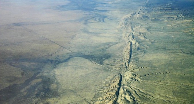
In a new finding utilizing GPS data, the San Andreas Fault has a 125-mile-wide “lobe” of “uplift and subsidence”. For years, vertical motion had been ignored because of the difficulty in interpreting the “noisy data” in tectonic investigations.
Crustal movement has been predicted using computer models simulating the San Andreas Fault System, but this new data shows vertical lift. EarthSpope Plate Boundary Observatory GPS data showed that over the past several years, the lobes that are on either side of the fault line have annual movement of a few millimeters.
Researcher Samuel Howell described it, “We were able to break down the noisy signals to isolate a simple vertical motion pattern that curiously straddled the San Andreas fault.”
With the recent seismic activity in California and Yellowstone, this type of modeling will be helpful in determining when and perhaps where along the San Andreas, the Big One could hit.
The 5.2-magnitude quake in Borrego Springs, woke up many sleepy Southern California homes. This quake was followed by 800 aftershocks. This number is abnormally high for aftershocks.
Head northeast, toward Yellowstone National Park and Montana, where just this past week, several quakes have hit the region. A magnitude 3.7 quake hit on June 9th, magnitude 4.3 on June 13th and on June 15th, a magnitude 4.0 shook the region.
Though Yellowstone is hit by earthquakes all the time, as it sits upon the Yellowstone super volcano, most of these quakes are extremely small. These higher magnitude quakes are unusual and disconcerting.
Drills are being conducted in the Pacific Northwest to prepare the area for an unprecedented earthquake disaster.
To prepare the Pacific Northwest for such an enormous disaster, the U.S. government has developed alongside the military and state and local emergency personnel a readiness drill the second week of June, a dress rehearsal for the prophesied massive earthquake and tsunami.
Cascadia Rising is what this readiness drill is being called, named after the 600-mile-long fault, the Cascadian Subduction Zone, which runs from Northern California to Southern British Columbia. The drill will involve 20,000 people, utilizing a wide range of governmental agencies, with the goal to test how well these agencies will work to decrease the loss of life and the destruction such an earthquake would leave.
Learn more about this “new modeling technique to “break down the noisy signals to isolate a simple vertical motion pattern that curiously straddled the San Andreas fault”, on the next page.
Wouldn’t be no lost.
Air force one was flying over California !!! It was Obama he’s so full of hot air he created the situation though he said it wasn’t his fault !!!
Bye Bye California !
Oh oh
According to Obama
Earth quakes are caused by liberals, they are deliberately weakening the plate boundaries with seismic geo engineering. They do this so that they can call for tougher seismic building standards which gives them more control over private property
The San Andreas Fault is like the perforation on a cracker. As soon as people get just so rotten in California, the Lord is going to snap it off and throw it into the ocean. Buy land in Barstow!