
Earthquake readiness is of great import in recent news, with Cascadia Rising drills that occurred early in June utilizing multi-government cooperation in the Pacific Northwest and into Canada. Perhaps the data coming out of University of Hawaii’s School of Ocean and Earth Science and Technology and the uptick in activity around the Ring of Fire has caused a needed stir in governmental readiness for a Big One disaster.
“The Ring of Fire is going through an alarming uptick in activity right now with 34 volcanoes erupting at the same time. The Ring of Fire a is 25,000-mile, horseshoe-shaped string of volcanoes and seismic activity sites around the edges of the Pacific Ocean. About 90% of all earthquakes and 75% of all active volcanoes are on the Ring of Fire.”
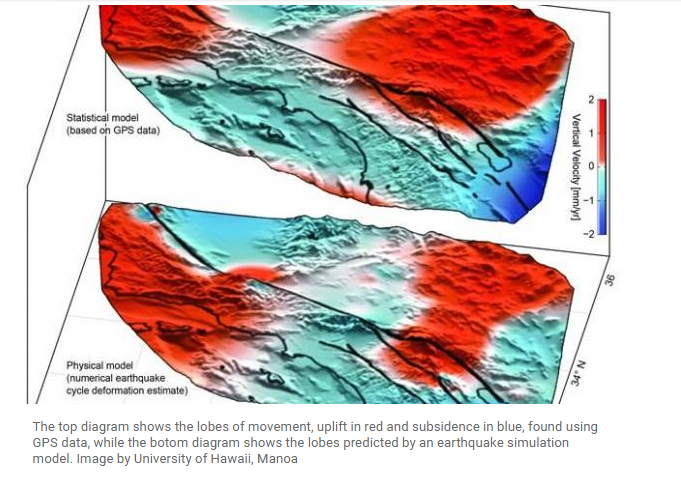
This new model, using GPS data which revealed “new areas of motions around the San Andreas Fault System”, used in conjuncture with previous predictive earthquake models, confirmed the “buildup of century-long earthquake cycle forces within the crust”.
Using data collected by the EarthScope Plate Boundary Observatory’s GPS array, researchers identified 125-mile-wide “lobes” of uplift and subsidence. Over the last several years, the lobes, which straddle the fault line, have hosted a few millimeters of annual movement.
Computer models simulating the San Andreas Fault System have predicted such crustal movement, but the areas of motion hadn’t been physically identified until now.
Researchers used advanced statistical modeling to identify the movement among the inevitable statistical noise that comes with monitoring minute movements in the Earth’s crust.
“While the San Andreas GPS data has been publicly available for more than a decade, the vertical component of the measurements had largely been ignored in tectonic investigations because of difficulties in interpreting the noisy data,” lead author Samuel Howell, a researcher at the University of Hawaii at Manoa, explained in a news release. “Using this technique, we were able to break down the noisy signals to isolate a simple vertical motion pattern that curiously straddled the San Andreas fault.”
The validity of the vertical patterns was confirmed by the fact that similar motions were predicted by an earthquake model designed by researchers at the University of Hawaii’s School of Ocean and Earth Science and Technology.
“We were surprised and thrilled when this statistical method produced a coherent velocity field similar to the one predicted by our physical earthquake cycle models,” said researcher Bridget Smith-Konter. “The powerful combination of a priori model predictions and a unique analysis of vertical GPS data led us to confirm that the buildup of century-long earthquake cycle forces within the crust are a dominant source of the observed vertical motion signal.”
This research could help scientists utilize the lesser lobes of vertical motion to help “predict more significant ruptures”. With the many earthquake zones across the United States and the consequential damage that is predicted with 8.0 magnitude quakes, being able to predict ruptures utilizing these lobes could be life saving. From the San Andreas, to the CSZ which on average produces magnitude 9.0 quakes every 500 years, to the The New Madrid seismic zone , the United States is in for a rocky future, should the predictions of enormous seismic activity come to fruition.
Source: UPI
Photo: Ikluft/Wikimedia
Wouldn’t be no lost.
Air force one was flying over California !!! It was Obama he’s so full of hot air he created the situation though he said it wasn’t his fault !!!
Bye Bye California !
Oh oh
According to Obama
Earth quakes are caused by liberals, they are deliberately weakening the plate boundaries with seismic geo engineering. They do this so that they can call for tougher seismic building standards which gives them more control over private property
The San Andreas Fault is like the perforation on a cracker. As soon as people get just so rotten in California, the Lord is going to snap it off and throw it into the ocean. Buy land in Barstow!